How underground utility mapping for construction projects can be a game-changer
Underground utility mapping is crucial to construction projects, ensuring that all subsurface utilities are accurately identified and documented before any ground disturbance begins. Underground utility mapping for construction is vital for preventing accidents, avoiding costly damages, and ensuring the safety of workers and the public. By understanding the precise locations of utilities such as water lines, gas pipelines, electrical cables, and telecommunications infrastructure, construction teams can plan and execute projects more efficiently and safely.
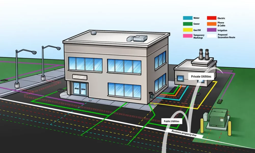
Understanding utility survey mapping
Utility surveys involve the detection, identification, and mapping of underground utilities. The primary purpose of these surveys is to create a comprehensive and accurate map that details the positions and types of subsurface utilities. This information is essential for construction planning, design, and execution, helping to avoid accidental utility strikes that can cause significant disruptions and hazards.
Accurate mapping of underground utilities is critical to enhance project planning by providing detailed information on the subsurface environment, allowing for better design decisions. Accurate utility maps help prevent delays caused by unexpected utility encounters and reduce the risk of costly damage repairs. Additionally, they ensure compliance with safety regulations, protecting both workers and the general public.
However, utility survey mapping is fraught with challenges. Inconsistent records pose a significant issue, as historical utility records may be outdated or inaccurate, leading to potential discrepancies in current mapping efforts. Complex subsurface conditions, particularly in urban environments with a dense network of utilities, make detection and mapping difficult. Technological limitations also play a role, as certain survey methods may have constraints in terms of accuracy and depth detection. Environmental factors such as soil conditions, weather, and other external elements can also impact survey accuracy.
The role of GIS in construction
Geographic Information System (GIS) technology is a powerful tool that captures, stores, analyzes, and visualizes spatial and geographic data. In construction, GIS is used to integrate various types of data, including topographical maps, utility locations, and environmental data, to support project planning and management.
GIS technology plays a pivotal role in construction projects by enhancing various aspects of project management and execution. It integrates and analyzes data from multiple sources, creating a comprehensive view of the project site. This holistic perspective allows construction teams to visualize potential issues and opportunities, aiding in better decision-making. GIS for construction also enhances communication by providing a shared platform where stakeholders can view and understand project details, fostering collaboration and alignment. Additionally, GIS also enables the real-time tracking of construction progress and changes.
Integrating GIS into construction processes offers numerous benefits. Enhanced accuracy is one of the primary advantages, as GIS improves the precision of site analysis and utility mapping, reducing the likelihood of errors. This accuracy increases efficiency by streamlining planning and coordination, minimizing delays, and reducing rework. Improved safety is another critical benefit, as GIS helps identify potential hazards and ensures compliance with safety standards, protecting workers and the public. GIS for construction contributes to cost savings by reducing the risk of utility strikes and the associated repair costs, ultimately leading to more successful and cost-effective construction projects.
Exploring software solutions for underground utility mapping
Underground utility mapping software is designed to detect, map, and manage subsurface utilities. These tools leverage advanced technologies such as Ground Penetrating Radar (GPR), electromagnetic locators, and GIS integration to provide accurate and detailed utility maps.
Underground utility mapping for construction enhances utility surveys with several key features. It includes data collection tools for capturing utility locations using Ground Penetrating Radar (GPR) and electromagnetic locators. The software provides advanced visualization capabilities to create clear, detailed maps of subsurface utilities. Data integration allows seamless merging with other data sources and GIS platforms, ensuring comprehensive datasets for better decision-making. It also features automated reporting for documentation and compliance, saving time and ensuring regulatory adherence. Collaboration tools enable easy sharing and coordination of utility maps with stakeholders, improving communication and project management.
Selecting the right utility mapping software is crucial for the success of construction projects. The right software should offer high accuracy, ease of use, robust data integration capabilities, and comprehensive support for various utility detection methods. It should also be scalable to meet the needs of different project sizes and complexities.
Benefits of utility mapping for construction
Prevention of accidents and damages
Accurate utility mapping prevents accidents by identifying the locations of hazardous utilities, such as gas pipelines and electrical cables. This allows construction teams to avoid damaging these utilities, which can cause serious injuries or fatalities, costly repairs, and project delays.
Efficiency in construction planning and execution
Utility mapping for construction enhances construction efficiency by providing detailed subsurface information that informs project planning and design. This reduces the likelihood of encountering unexpected utilities, minimizing disruptions and ensuring a smoother construction process.
Ensuring regulatory compliance and safety standards
Underground utility mapping for construction ensures compliance with regulatory requirements and safety standards by providing accurate and up-to-date utility information. This helps construction companies meet legal obligations and maintain high safety standards, protecting both workers and the public.
PointMan: The ideal mapping software for underground utilities
PointMan is a premier critical infrastructure mapping software that offers comprehensive solutions for detecting, mapping, and managing subsurface utilities. Its robust features cater specifically to construction industry needs. It includes real-time data capture, which collects and processes utility data instantly using GPS and other detection technologies. The software provides detailed 3D visualization, enabling better planning and visualization of underground utilities. Seamless integration with GIS platforms enhances data analysis and management, while cloud-based collaboration tools allow for easy sharing and teamwork on utility maps with stakeholders. PointMan’s automated reporting generates detailed documentation for compliance and regulatory purposes, streamlining the reporting process.
PointMan effectively addresses common challenges in utility mapping. It improves data accuracy by utilizing advanced detection technologies to provide precise utility locations. The software enhances data management with robust integration and management capabilities, ensuring all relevant information is consolidated. Facilitating collaboration is another key strength, with cloud-based tools that make sharing and teamwork straightforward.
Underground utility mapping for construction is essential for the safety, efficiency, and success of construction projects. Accurate utility maps prevent accidents, reduce costs, and ensure regulatory compliance. PointMan stands out as the ideal software solution, offering advanced features and capabilities that address the common challenges of utility mapping. By investing in PointMan, construction professionals can enhance project planning, execution, and safety, ultimately leading to more successful and efficient construction outcomes.